

Preview
Circa Date
circa 1887
Transcription
38
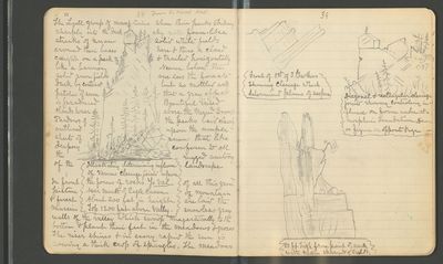
[sketch: Illustrating determining influence of various cleavage joints upon the forms of rocks. Yo Val [Yosemite Valley] near mouth of Eagle Canon. About 200 feet in height. Top 1200 feet above valley.]
From the north wall, The Lyell group of mountains show their peaks striking sharply into the dark sky with foam-like streaks of snow solid white fields around their bases here & there a cloud caught on a peak & trailed horizontally like a banner Nearer below the solid snow fields one sees the forests dark by contrast but so mottled with patches of snow that a gray effect is produced Beautiful irised clouds hover above the Merced Group Shadows of the peaks laid clearly outlined upon the ample sheets of snow that like drapery conform to all the rugged anatomy of the landscape
In front of all this grand picture of mountain & forest are laid the massive snowless gray walls of the valley which swoop majestically to the bottom & plant their feet in the meadows & groves
The river shines & in every rapid the sun is sowing a thick crop of spangles. The meadows
39
[sketch: Front of 1st of 3 Brothers showing cleavage which determined planes of surface]
[sketch: Diagonal & rectangular cleavage joints showing controling [controlling] influence on form under atmospheric denudation. Same as figure on opposite page.]
[sketch: 80 ft [feet] high from point of [unity] with main spur W [west] of Eagle Pt [Point]]
Date Occurred
1872-1874
Resource Identifier
MuirReel32 Notebook01 Img022.Jpeg
Contributing Institution
Holt-Atherton Special Collections, University of the Pacific Library
Rights Management
To view additional information on copyright and related rights of this item, such as to purchase copies of images and/or obtain permission to publish them, click here to view the Holt-Atherton Special Collections policies.
