

Preview
Transcription
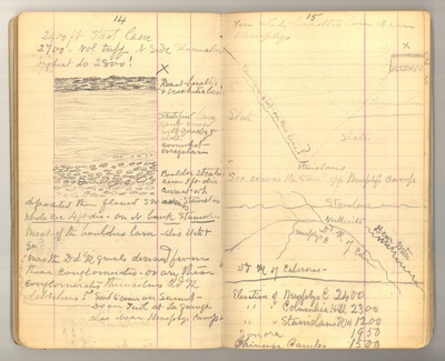
14 2400 ft Strat [Cave] 2700 vol tuff N [North] side Stanislaus Highest do [ditto] 2800!
[sketch] Recent basaltic & [trachytic] [Can] Stratified lava sand mixed with quartz & slate. somewhat irregular Boulder [stratification] some 1 ft dia [diameter] current wh [which] deposited [then] flowed SW [across] Stanislaus Whole sec [section] 4 ft dia [diameter], on N bank Stanislaus Most of the borders lava, also slate & qu [quartz]?
Was the Dd [Dead] R [River] [gravels] derived from these conglomerates, or are these conglomerates themselves Dd R [Dead River] detritus? Said to occur on Summit
Do [Ditto] on Tuol [Tuolumne] at La Grange also near Murphys Camp
15
[Fine] white basaltic lava Near Murphys
[sketch: Stanislaus cut on this line?; slate; [ ]]
Sec [Section] across the Stan [Stanislaus] opp [opposite] Murphys Camp
[sketch: [Stanislaus]; Vallecito; Bear Mtn [Mountains]; Dd R of Calaveras; Murphys C [Camp]; Dd R of Calaveras]
Elevation of Murphys C [Camp] 2400 [Elevation of] Columbia Hill 2300 [Elevation of]Stanislaus R [River] lol [between] 1200 Sonora 1950 Chinese Camp=1500
Date Original
1876
Source
Original journal dimensions: 10 x 16.5 cm.
Resource Identifier
MuirReel25Journal01P14-15.tif
Publisher
Holt-Atherton Special Collections, University of the Pacific Library
Rights Management
To view additional information on copyright and related rights of this item, such as to purchase copies of images and/or obtain permission to publish them, click here to view the Holt-Atherton Special Collections policies.
Keywords
John Muir, journals, drawings, writings, travel, journaling, naturalist
