

Preview
Transcription
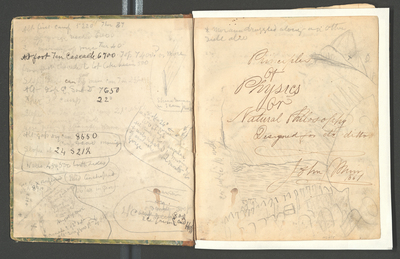
Alt [altitude] first camp 5220 Ther [thermometer] 37
“ top gorge reached 6000
2 morning top gorge Ther [thermometer] 40° [degrees]
Alt [altitude] foot Ten [Tenaya] Cascade 6700. Top 7400? or more from foot cascade to bot [bottom] lake basin 500
Slope Right can [canyon] [top] end main can [canyon] Ten [Tenaya] 23 ½
Alt [altitude] [Gap] E. [east] South D [Dome] 7650
Ther [thermometer] 3rd camp 22° [degrees]
Slope can [canyon] Ten [Tenaya]near 3rd camp 21° N. [north] side
About same S. [south] side
Here [power] of cleavage shown
Alt [altitude] gap dry can [canyon] 8550
Camp 8000 [moving]
Slope N [north] 24 S [south] 21 ½
Walls 450, 500 both sides
Mid lenshaped so all in [cen]
Sec [section] of overflow alt [altitude] of 8900
[sketch: N65; moraine from E [east] end Hoff [Hoffman] [ ] [right] [Lat] [ ] of [Dana] gl [glacier] Right of mor [moraine]; cascades E [east] of 2nd Wat [Watkins] Alt [altitude 2000, 1800 ft [feet] 400
[sketch: stream running in S [south] can [canyon] [Rock]
[sketch: Slope 26° [degrees] 100 ft high All kinds of rock singular & waterwashed by [melting] of avalanche at mouth of gorge]
[can stream]
Dry
[ ] 300 ft
4th camp deep 800 ice [ ] E [east] end Hoff [Hoffman]
*moraine dragged along on other side [ ]
Principles of Physics or Natural Philosophy Designed for etc. ditto John Muir 1861
[sketch of mountain: SE [southeast]; 25 feet [ ] 10 wide]
Date Written
1861-01-01
Contributing Institution
Holt-Atherton Special Collections, University of the Pacific Library
Rights Management
To view additional information on copyright and related rights of this item, such as to purchase copies of images and/or obtain permission to publish them, click here to view the Holt-Atherton Special Collections policies.
