

Preview
Reverse Side Caption
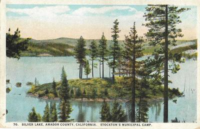
Silver Lake, California, Stockton, Municipal Camp. El Doarado National Forest, Califronia, is located 100 miles from Stockton at Silver Lake, Amador County on the Apline Highway, Elevation 7,240 feet.
Contributing Institution
Holt-Atherton Special Collections, University of the Pacific Library
Resource Identifier
3372
Circa Date
circa 1940
Rights Management
To view additional information on copyright and related rights of this item, such as to purchase copies of images and/or obtain permission to publish them, click here to view the Holt-Atherton Special Collections policies.
Keywords
San Joaquin County, Stockton California, photographs, postcard, photo, image, history, Western America

Geographic Coordinates
38.633546, -120.127583