

Preview
Transcription
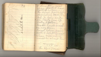
94
[Sketch]: opp [opposite] Trail N [North] Side KR can [Kings River canyon]
95
& down by good easy graded sandy trail to bottom
The highest point before descending 8500 ft not 1/2 hour walk on trail from
top valley to bottom.
Several small meads [meadows] on way down.
Passed between main wall & high pt [point] [9000] ft whose cross [section] would [be] about [thus].
[sketch of arrow pointing to left]
S 35 W Mag [magnificent]
the top is [granite]
Date Original
1873
Source
Original journal dimensions: 8 x 12 cm.
Resource Identifier
MuirReel24Journal03P094-095.tif
Publisher
Holt-Atherton Special Collections, University of the Pacific Library
Rights Management
To view additional information on copyright and related rights of this item, such as to purchase copies of images and/or obtain permission to publish them, click here to view the Holt-Atherton Special Collections policies.
Keywords
John Muir, journals, drawings, writings, travel, journaling, naturalist
