

Preview
Transcription
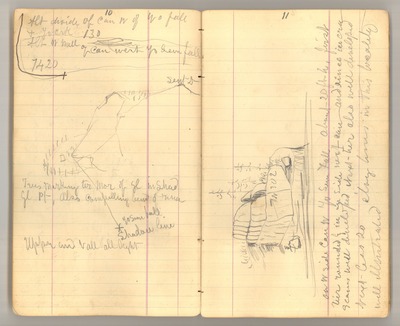
10 Alt [Altitude] divide of can [cañon] W [west] of Yo [Yosemite] fall & Yo Crk [Yosemite Creek] 130 Alt [Altitude] W [west] wall of can [cañon] west Yo Sem [Yosemite] fall 7420 [sketch: Sent D [Sentinel Dome]; Yo Sem [Yosemite] fall shadow line] Trees marking ter mor [terminal moraine] of gl [glacier] in shad [shadow] Gl Pt [Glacier Point] Also compelling bend of river Upper [end] Vall [Valley] all light 11 [sketch: N30E] On W [west] side can [cañon] W [west] Yo Sem [Yosemite] Fall About 20 ft [h] [high] first tier rounded by ice on side next can [cañon] and since ice [era] seems well developed Next tier also well developed Next less so clvg [cleavage] lines in this locality well illustrated
Date Original
1873
Source
Original journal dimensions: 10 x 16.5 cm.
Resource Identifier
MuirReel23Journal11P010-011.tif
Publisher
Holt-Atherton Special Collections, University of the Pacific Library
Rights Management
To view additional information on copyright and related rights of this item, such as to purchase copies of images and/or obtain permission to publish them, click here to view the Holt-Atherton Special Collections policies.
Keywords
John Muir, journals, drawings, writings, travel, journaling, naturalist
